- CSS News
- Environmental Resource Assessment & Management
Presenting and Networking at Coastal Geotools 2023
Several of our employee owners attended the Coastal Geotools conference in Charleston, SC. This conference is the largest conference for coastal resource managers focusing on data, tools, technology, and other geospatial solutions coastal managers need to serve their communities. With many of our staff and potential employee prospects in attendance, we provided a bronze sponsorship and staffed a booth to discuss our company and project examples with the coastal management and geospatial community. Several staff presented their projects including offshore wind site suitability modeling, and ocean economy and offshore planning data development. In addition, staff provided tool demonstrations during the Tool Showcase.
This conference enables our staff to learn new skills and approaches from their peers, and expand their networks within the geospatial community.


See More CSS Insights

55 Years of Earth Day!
Since April 22, 1970 — that’s 55 years! — we’ve celebrated Earth Day to raise environmental awareness and support for environmental protection. At CSS we have a passion for the environment and through various government contracts, we work with our clients to overcome challenges to help protect this rock we call home. Below are a…
CSS Awarded Five Year Subcontract Supporting the Bureau of Engraving and Printing
For over 22 years, CSS has supported the Bureau of Engraving and Printing (BEP). Originally as a prime contractor, CSS began supporting BEP in 2002. In November 2024, a new prime contractor, Koniag, signed CSS as a major subcontractor, which enabled CSS employee owners to continue providing comprehensive environmental, occupational safety and industrial hygiene support…
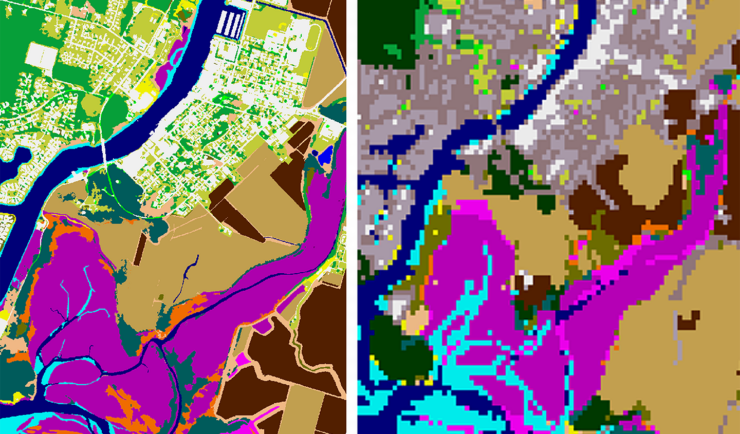
New Heavily Desired High Resolution Land Cover Data for the U.S.
The National Oceanic and Atmospheric Administration recently announced the launch of the long desired high-resolution coastal land cover data. This highly anticipated data are available for most coastal areas of the U.S., including Alaska and the U.S. territories. CSS employee owners contributed to the release of this data set by participating in production activities and…