- Success Stories
- Environmental Resource Assessment & Management
Expanding Our Offshore Wind Team

We’ve recently added several staff to bolster the offshore wind team at NOAA’s National Centers for Coastal Ocean Science. With this full team of 13, our employee owners are able to provide more focused support in their areas of expertise, including mapping and spatial modeling, data collection, communications, project management, and partner engagement. Through this work, the team develops regional ecosystem-wide spatial models to inform siting of ocean use sectors, environmental review, and permitting, which provides guidance to the Bureau of Ocean Energy Management (BOEM) on suitable locations for offshore wind siting.
Sustainable coastal planning and development increases resiliency, creates jobs, reduces reliance on unsustainable imports, supports renewable energy, and grows the domestic Blue Economy. Check out the NCCOS Coastal & Marine Planning and Offshore Wind Energy spatial planning webpages to learn more.
This team is now providing spatial planning support in all U.S. ocean regions and was recently instrumental in BOEM designating two Wind Energy Areas in the Gulf of Mexico. As offshore wind continues to expand throughout U.S. waters, this team will continue to collaborate with BOEM to support the identification of suitable locations for renewable energy. Future work is slated for the U.S. Central Atlantic, Gulf of Maine, Oregon, and more to come!
See More CSS Insights
Providing Data Products for More Effective Consumption
The National Oceanic and Atmospheric Administration’s (NOAA) National Centers for Environmental Information (NCEI) is responsible for providing data, products, and services that help businesses and organizations operate more efficiently and effectively. As such, these data and products need to be available in a publicly accessible and digestible format the audience are able to understand. To…
Emergency Response Support for the Republican National Convention
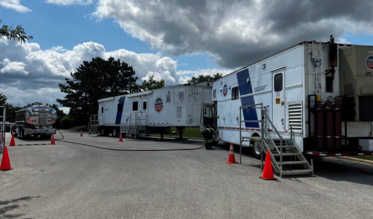
CSS employee owners on contract with the U.S. Environmental Protection Agency’s Portable High-throughput Integrated Laboratory Identification System — a mobile analytical unit known as PHILIS — provided emergency response support for the 2024 Republican National Convention. PHILIS mobile laboratory units are designed to provide onsite analysis of environmental conditions, including air and soil samples, contaminated…
Happy 50th Birthday, Coastal Zone Management Act!
The Coastal Zone Management Act turns 50 this year! Many of our National Oceanic and Atmospheric Administration (NOAA) contract teams support this important piece of legislation. We have staff on the ground in many geographies working with state and U.S. territorial coastal programs. These staff work closely with these programs to provide guidance and support…